
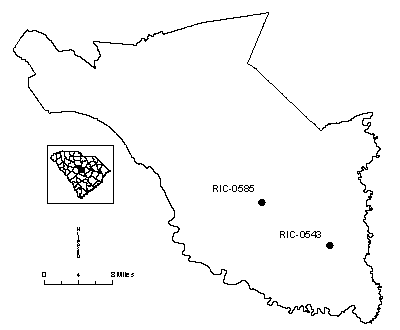
Monitoring Wells in Richland County
Click well ID to retrieve daily average groundwater levels
| Well ID | Elevation | Latitude | Longitude | Depth | Aquifer | Status |
|---|---|---|---|---|---|---|
| RIC-0543 | 183.82 | 33 52 30 | 08 04 09 | 420 | Middendorf | Actively monitored continuous ADR site |
| RIC-0585 | 328.04 | 33 56 56 | 08 05 27 | 403 | Middendorf | Actively monitored continuous ADR site |
| RIC-0775 | 150 | 33 50 14 | 08 03 31 | 607 | Middendorf | Actively monitored continuous ADR site |
| RIC-0776 | 150 | 33 50 14 | 08 03 31 | 107 | Black Creek | Actively monitored continuous ADR site |
| RIC-0794 | 220 | 33 56 39 | 80 39 56 | 100 | Crouch Branch | Actively monitored manual site |
| RIC-0799 | 220 | 33 56 39 | 80 39 56 | 318 | McQueen Branch | Actively monitored continuous ADR site |
Status column:
ADR: Water level is continuously measured on an hourly basis.
Manual: Water level is periodically measured on a bi-monthly basis.
Inactive: Water level is not currently monitored.
Abandoned: Well has been permanently abandoned and water levels can no longer be measured.